Day 5 Gargrave to Fountain's Fell
22.5km, 794 metres ascent, 7 hours 40 minutes
 |
| Malham Cove |
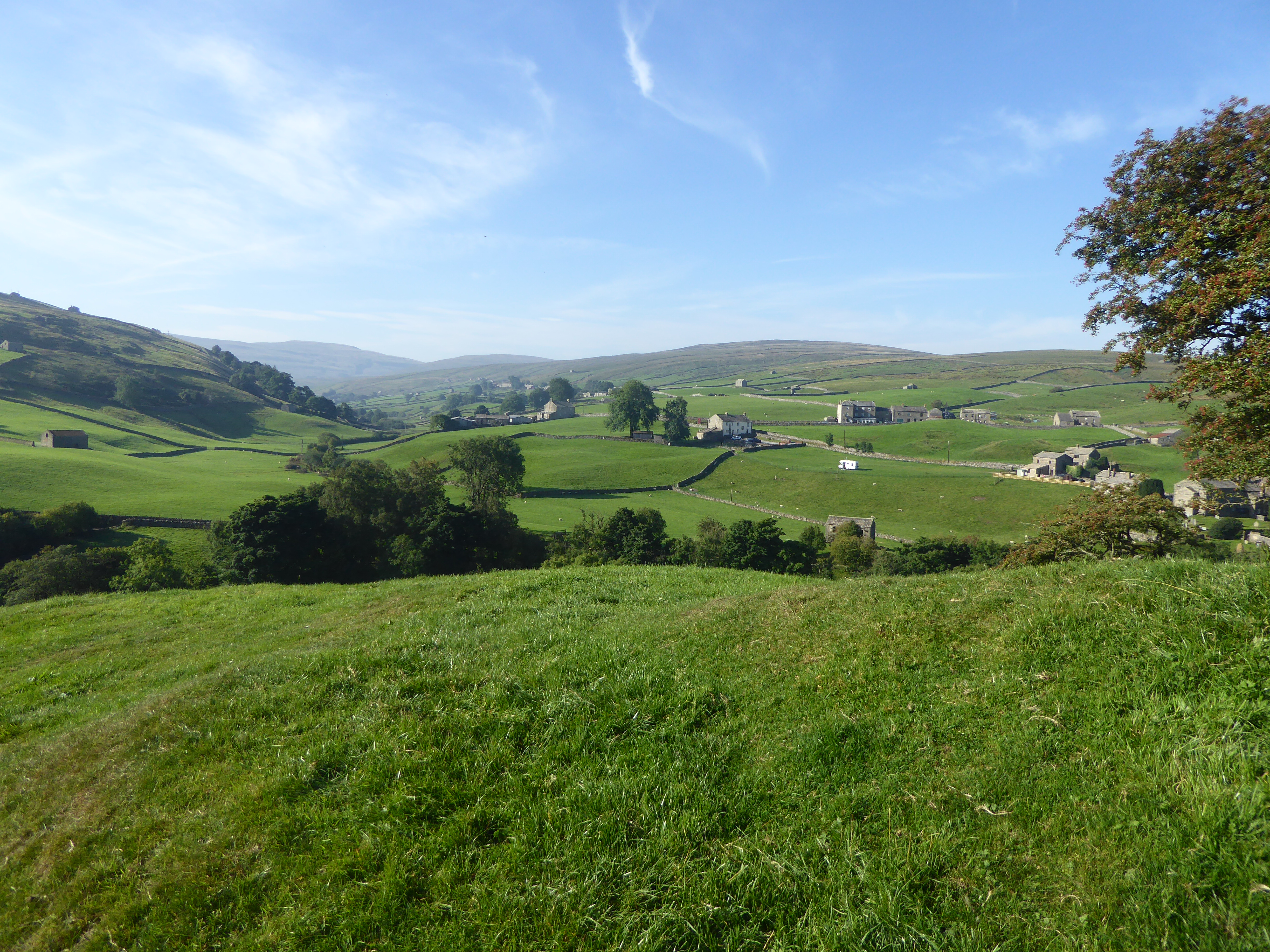
Now listen. Well you can't actually listen because I'm not really speaking, but in my head I'm talking to you. If you have never walked the Pennine Way and fancy doing so, but you do not think you can manage the whole thing, you may like to try heading north for
a few days from Gargrave. This
section is wonderful. The best. Simply the best. You leave the village and head
off through gorgeous fields, yes lowland scenery, but still northern England at its picture postcard best. Eventually you will follow the River Aire to Malham in the knowledge that when you get there you still have much more to come.
And the best is not even the availability of rolls filled
with pork and poultry products at one of Malham’s cafes, although John and I
arrived there at mid-morning, a civilised time to drink pots of tea and
replenish ourselves with egg and bacon and sausage filled rolls. Furthermore, the sun
was out. Big time. It was getting really warm. I wished I’d donned shorts and a
thinner shirt but being over warm was a small price to pay.
 |
| I'm enjoying this |
We joined the Sunday day tripper crowds on the walk from the
village towards Malham Cove to take similar pictures to those that have appeared
in every Geography O Level or GCSE text book that has ever been published.
Upland limestone scenery. Or ‘karst scenery’ if you are German and reading this
(are you Nathalie?).
John bounded up the steep rock steps that make up the path
to the top of the cove. I half bounded up them and then it was into more limestone
loveliness as we walked through the impressive dry valley by Ing Scar crags and
on to Malham Tarn. Despite setting off carrying a large amount of water I was
already starting to get dehydrated thanks to the heat and the steep climbs but
there was an ice cream van selling cans of pop and then we lazed on the grass by the tarn and ate
lunch and popped Ibuprofen for aching shoulders.
 |
| John on the limestone pavement above Malham Cove |
 |
| Looking back along the Pennine Way in Ing Scar |
 |
| Fountain's Fell wild camp: one of the best |
Day 6 Fountain’s Fell
to Cold Keld Gate
24.6km, 779 metres of
ascent, 8 hours 35 minutes
The day started murky. Pen-y-ghent loomed, looking ominous.
As you walk towards it your eyes are drawn to its steep southern edge which dominates the sky
line, and which you are going to have to climb. If you have never climbed Pen-y-ghent, and I hadn’t, you can be assured
that it’s true what almost everyone who has been up that route says. It is
nowhere near as bad as it looks. The last hundred metres or so is a steep, but easyish, rocky scramble, although as I have aged, and my leg muscles have become more
feeble, I find some of the bigger step ups when wearing a full pack lead to my
knees seeing far more contact with the rock than they once would have done. Not
elegant but it gets me there with a few anxious moments and a little huffing and puffing. John, however, seems
to glide over such minor obstacles in a way I never could have done, even 30
years ago. Anyway, we were at the top 75 minutes after starting out.
 |
| Pen-y-ghent: short, steep but sweet |
 |
| Trying not to look a little tired at the summit of Pen-y-ghent... |
 |
| ...whereas John didn't have to try |
Horton-in-Ribblesdale followed an hour or so later. No cafés there now since the once legendary Pen-y-ghent café shut down. Another lockdown casualty? We were reduced to eating cereal bars and M and Ms and stuff on the pavement when what we really needed was a sit down with rolls filled with sausage, bacon and egg, smothered in tomato ketchup and washed down by lashings of strong English Breakfast. However, we were brave little soldiers and didn’t complain.
 |
| The Way is generally reasonably well signed, although as always these things are least in evidence in some of the places where they are most needed |
We continued north across the limestone, passing pot holes, sink holes and more limestone pavement. Ling Gill Bridge saw us at the last place we were confident we could get water for the rest of the day and for dinner, overnight, breakfast and the walk on to Hawes. We filled up and loins were girded to carry the extra weight for the next 6km, heading up to the Cam Road which is now a fairly unpleasant long, straight, badly surfaced high level track used by forestry vehicles. It’s a bit of a trudge but hey ho. Our decision to lug the water proved to be the right one, as the couple of springs and small streams shown further along on the map were all dry. At Kidson Gate John raced up and down, backwards and forwards next to a dry stone wall and after some poking around returned in triumph carrying two gas cartridges that he had hidden a couple of weeks earlier. Our plan had been to camp at Kidson Gate or a little further along the track towards Hawes. I was pretty done in by now so stood around uselessly whilst John bounded up the hillside to check out likely spots for our tents, but with no joy. Fortunately, we’d noticed a couple of possible pitches a few minutes back along the Cam Road so doubled back to Cold Keld Gate and found two pretty decent Duomid sized pieces of level ground just off the Pennine Bridleway. Result!
 |
| Red Moss Pot (I think) |
 |
| Ling Gill Bridge: The last stream running so we carried water from here for our overnight camp 6km further on |
 |
| Cold Keld Gate wild camp |
 |
| The view from my sleeping bag as the sun went down |
 |
| John on sunset watch |
Day 7 Cold Keld Gate
to Usha Gap Camp Site
25.1km, 618 metres
ascent, 9 hours
 |
| Lovely Hawes: Pies and other pork products were purchased in bulk |
It was just a couple of hours to Hawes from Cold Keld Gate so
we were in town by 9.30am. John, obviously craving pork products, headed
straight for an excellent butchers (or was it a bakery?) that he knew.
Whatever, it sold pies full of the stuff. Other meats were also available. We
then headed to various other shops including the supermarket. Supermarket? Not
in quaint Hawes. That’s a grandiose term for the Spar. We then did what the
majority of backpackers do after a week of calorie deficit. We bought too much
food. I was still eating flapjack from here over a week later in Kirk Yetholm
and it was just as delicious then.
Still craving food and fluids we sat in the sun outside a café and had more pork filled rolls. Sadly, the sausages tasted like they had been grilled each day for a week before being served up to us, but we didn’t care – we had pies in our packs for later.
 |
| Through the fields to Hardraw |
The walk over the fields to Hardraw provided more Dales
loveliness with the added bonus of hardly any uppity bits. But then there was a
very long drawn out uppity bit, Great Shunner Fell, which was delightful
despite the hot sun, and despite the uppityness and the drawn outness.
Now John had spent a week walking at my pace with no outward
sign of irritation and, indeed, he seemed remarkably chilled about this. I couldn’t
have shown such patience with a companion. Feeling guilty about this when we were a
kilometre or so from the top, I removed the hobbles I’d tied to his legs,
unfastened the lead from the choke chain around his neck and told him to go on ahead,
asking him to time his arrival at the summit and then to note mine. Which he
did. I cannot recall the exact results of this experiment but seem to remember
that I had in advance reckoned his pace to be at least 50% faster than mine and
this seemed to be proved about right. In fact I suspect he was still, by his
standards, dawdling as he climbed upwards.
I hadn’t waited until the summit to start consuming pie but still had some left when I arrived and we both lay on the grass in the sun, propped up against our packs, eating pies and generally loving the day.
 |
| At the summit of Great Shunner Fell I inherited my shorts from Eric Morecambe. John didn't. (Mine are the Montane 'Razor' model. It should be said that they are extremely light and comfortable and recommended to anybody who doesn't care if they look like a complete pillock) |
 |
| Heading for Thwaite after Great Shunner Fell |
Later we headed down to Thwaite, 6 km in hot sun with little water left but where we found the Kearton Hotel-café-cum-bar open. Smiley face emoji. Beer glass emoji.
After the rehydration exercise (it was tough but had to be done) we left the Pennine Way for a kilometre or so and
headed to Usha Gap camp site near Muker. It provides a superb stopover for backpackers.
A shop, excellent showers, laundry, drying room, secure lockers with phone
chargers, flat pitches and all for £8 per head. Use it if you are in the area.
 |
| A badly needed rehydration stop in Thwaite before the last kilometre to the camp site |
 |
| Through the fields to Usha Gap |
 |
| Usha Gap camp site: Highly recommended, great facilities, great value, great place to clean up and recharge |
Day 8 Usha Gap to Deepdale Beck
24.5km, 688 metres
ascent, 8 hours 50 minutes
This was the day we left the Dales of Yorkshire and crossed into
the Dales of County Durham with their wilder and more remote feel. The two
significant landmarks today were to be the Tan Hill Inn and then God’s Bridge and the
halfway point of the Pennine Way just before crossing the A66.
 |
| Yorkshire Dales scenery: looking back as we headed towards County Durham |
 |
| Approaching Tan Hill |
I bought the first round. John, who clearly cannot take his beer in the morning went to get his round in and managed to stumble on a step causing a potential disaster as the sole of his boot came away at the toe. These were almost brand new boots, purchased not long before our trip. And on examination he found that his other boot had also developed a split, nothing to do with his single pint of beer fuelled slip. Gaffer tape was applied as a temporary fix but we still had about 140 miles and 9 more days of walking. We spent much of the rest of our stop at the pub discussing potential contingency plans in the belief that the next shop that might sell new boots was in Alston, four days away. Courier a pair up from home? Further temporary repairs with materials to be bought the following day in Middleton to get us to Alston? Hope for the best?
 |
| See that step in the background? That came close to causing us a major problem. That and John being unable to hold his beer |
Sleigtholme Moor. Miles of it. A featureless, boggy nightmare, apparently, in wet conditions. Fortunately, we had had a dry summer and it was merely a little dull. And featureless. Did I mention that? Our navigation went a little astray after the worst of the moor was over. This was because I was lovingly explaining my 35 year career in public service to John in fascinating detail and John was too engrossed by my tales of why the public sector was all the better for my presence and had lost true genius when I retired to look at the map. I had just got to 1987 when we spotted our mistake, but could rectify it before too much distance damage had been done. We headed on to God’s Bridge, and soon after to the half-way marker on which some wag has scrawled the witty remark “suckers” aimed at Pennine Way through hikers. Possibly we are, but I know whose life I would rather be living and it’s not that of the pathetic prat with the permanent felt tip pen who probably spends his life watching box sets on Netflix.
 |
| Sleightholme Moor (Yes it is as dull as it looks, but at least it was pretty dry when we crossed it) |
 |
| The stream at God's Bridge |
 |
| 135 miles down. Half Way! The tunnel under the A66 |
Deepdale Beck was our intended camp spot and we had rightly assumed it would be substantial enough to have water in it. Better still it had a walkers’ shelter, so credit to the estate which provides it. And the shelter has chairs in it. So we borrowed a couple and luxuriated on them as we cooked evening meals before having to hide behind the midge nets in our inners as the bitey things came out to end our evening in the sun.
 |
| Wild camp by the shooting hut and walkers' shelter at Deepdale Beck |
 |
| Luxury. A proper sit down thanks to the chairs in the walkers' shelter |
I'm enjoying this narrative, David. I'd planned to do the Pennine Way myself, but a heel injury prevents that, so I'm enjoying the vicarious walk.
ReplyDeleteGlad you are enjoying it Martin. If I remember when I get to the end of these posts I will provide some reflections on the walk along the lines of "would I do it again?" I hope your heel injury clears soon.
ReplyDeleteSlagging off Sleightholme Moor? I loved it!
ReplyDeleteSee HERE
Chairs. Now that's posh.
But you are a bit eccentric (that's code for 'weird'. :-)
DeleteI love the MAMBA acronym you used. I'll try to remember that! It could make TGOC write ups shorter. 🤣🤣🤣
I'm enjoying these reports, most entertaining.
ReplyDeleteI too like the empty windswept grasslands around the Stainmore Gap, perhaps it's an acquired taste!.
I am yet to acquire it, Geoff. Each to his own :-)
DeleteYou were certainly blessed with good weather - if a little warm!
ReplyDeleteIs that a new tunnel under the A69? I don't recall it from when I last did the PW, a few years ago.....actually *quite* a few years ago.
Next please, I'm enjoying this!
Argggh. Sorry JJ. I meant the A66 not the A69. Senility has arrived (me not you!).
DeleteThe weather was, indeed, rather clement for most of our walk John. The tunnel under the A69 has been there for a good few years but I'm not sure how many. Johnboy certainly had to take his life in his hands to dash across the carriageway when he made his previous crossings in the 1980s.
ReplyDeleteThe next post is imminent.
That tunnel went under the A66, surely?
ReplyDeleteGosh yes. Of course. Thanks Phil. I'll amend. I have driven along both the A66 and A69 hundreds of times. No idea how I made that mistake.
Delete