Wednesday 27 October 2021

Pennine Way Days 9 to 12: Deepdale Beck to Knarsdale: The Kindness of Strangers

Day 9 Deepdale Beck to Middleton-in-Teasdale

14.1km, 388 metres of ascent, 3 hours 55 minutes

Near Blackton Reservoir, Baldersdale

This was a short day of pleasant walking but not especially memorable. We passed through Hannah's Meadow (that's a linky thing there about Hannah) in Baldersdale. John had camped at Hannah Hauxwell’s on one of his Pennine Way walks in the 1980s before television made her an unlikely star. John walked with his patched up boot, fortunately with the duck tape still holding the sole to the upper.


Grassholme Reservoir - evidence of our unusually dry summer

John's Boot, illustrating one of the many uses for duck tape - I always carry some wrapped around my walking poles

Middleton-in-Teesdale. We arrived well before midday and headed to the first café we saw. At the counter my brain said “We would like two large mugs of tea and two wholemeal rolls, the latter filled with the finest of fried local pork produce topped with a Size 3 free range. Oh, and kindly ensure that the roll is generously, nay lavishly spread, with lashings of unsalted butter and that the whole ensemble is then smothered in the very best tomato ketchup that Heinz produces. And make it snappy my good woman for our need is greater than the old ladies sitting here who have done nothing other than pop to the local Co-op this morning”. In fact I simply asked for a couple of mugs of tea with bacon and egg rolls and a plastic sachet of ketchup. But they still tasted damned good.

The Teesdale Hotel, our luxury* accommodation for the night would not allow us to enter until 3 pm. This gave time for John to pop to Raine’s Hardware store to try to buy boot repair products.

(* The use of the word "luxury" may not be entirely accurate. "Adequate" might have been better, although to be fair hospitality venues have had a torrid couple of years)

Raine’s is the sort of hardware shop that appeals to the middle aged and elderly. One of those places you find in many small towns. They sell everything, from children’s toys in faded boxes that have sat in the shop window since 1969, to plastic flowers, to dustbins, assorted nuts and bolts that can be bought singly rather than in packs of two hundred…and…amazingly, and hidden away upstairs in Raine's,…walking boots. Eureka. John now had the choice of two pairs. One pair by a well-known manufacturer costing two squillion pounds and one by “Hogg’s of Fife” costing somewhat less. Having lots of pairs back at home, and only needing something to last for another week he opted for the latter, and parcelled his ruined pair up to post home to do battle with the manufacturers, if necessary with the support of the Sale of Goods Act.

Apart from the normal B and B stuff like the much needed shower, washing our smalls and then heading off to stock up at the Co-op, the only other noteworthy mention of our stop in Middleton was the fabulously delicious meal we had at Forrester's French Bistro opposite the hotel. I had scallopy things followed by maple smoked duck breast in some saucy* stuff if you’re interested. You’re not? Well I won’t tell you what I had for pudding then.

(*That's not "ooo matron saucy", it's sauce saucy, sauce in this context meaning very fancy gravy). Do click on the linky thing there. 


Day 10 Middleton-in Teasdale to High Cup Nick

26.5km, 688 metres of ascent, 7 hours 35 minutes

What a brilliant day's walking, in great walking weather. Mainly dry, a little sun, and just the right temperature. Absolutely fabulozy. Much of the way followed the River Tees upstream.


Low Force(ish) on the River Tees


High Force (with no "ish" about it)


Following the Tees upstream

The scenery was wonderful. And it features well known landmarks such as Low Force, High Force and then onward through the Upper Tees Valley, which feels pretty remote and wild apart from the occasional farm. The path gets quite bouldery in places and is a little tricky for the unbalanced (mentally and physically in my case). John entertained himself by going ahead and then taking photos of me each time I slipped, grimaced or generally made myself look a pillock. He seemed to take delight in sneaking these out on Facebook at the earliest opportunity. Cauldron Snout was reached. It is very impressive. The path up the side involves a scramble, which would be easy wearing just a day pack but far less so for an old bloke with a large backpack. John floated upwards and was at the top whilst I was still huffing and puffing well below. I’ve commented before on John’s ability to go up fairly steep rock without touching it with his hands. By coincidence I came across this two minute video of legendary rock climber Johnny Dawes the other day. Click on that linky thing and be amazed. I am not suggesting Johnboy could manage a full on rock climb without using his hands but the video is still worth a watch in its entirety for the jaw dropping skill in evidence.

The Upper Tees Valley


Cauldron Snout

The weather was starting to look ominous by the time we arrived at High Cup Nick. We got the Duomids pitched on a platform high above the east side of the valley and then headed off to take photographs of this spectacular feature. This is a very definite highlight of the Pennine Way, but the whole walk from Middleton is just superb. And as it turned out it was a good job we took our pictures then for soon after the wind came up and the heavens opened. Big time. And as for the weather the following morning…


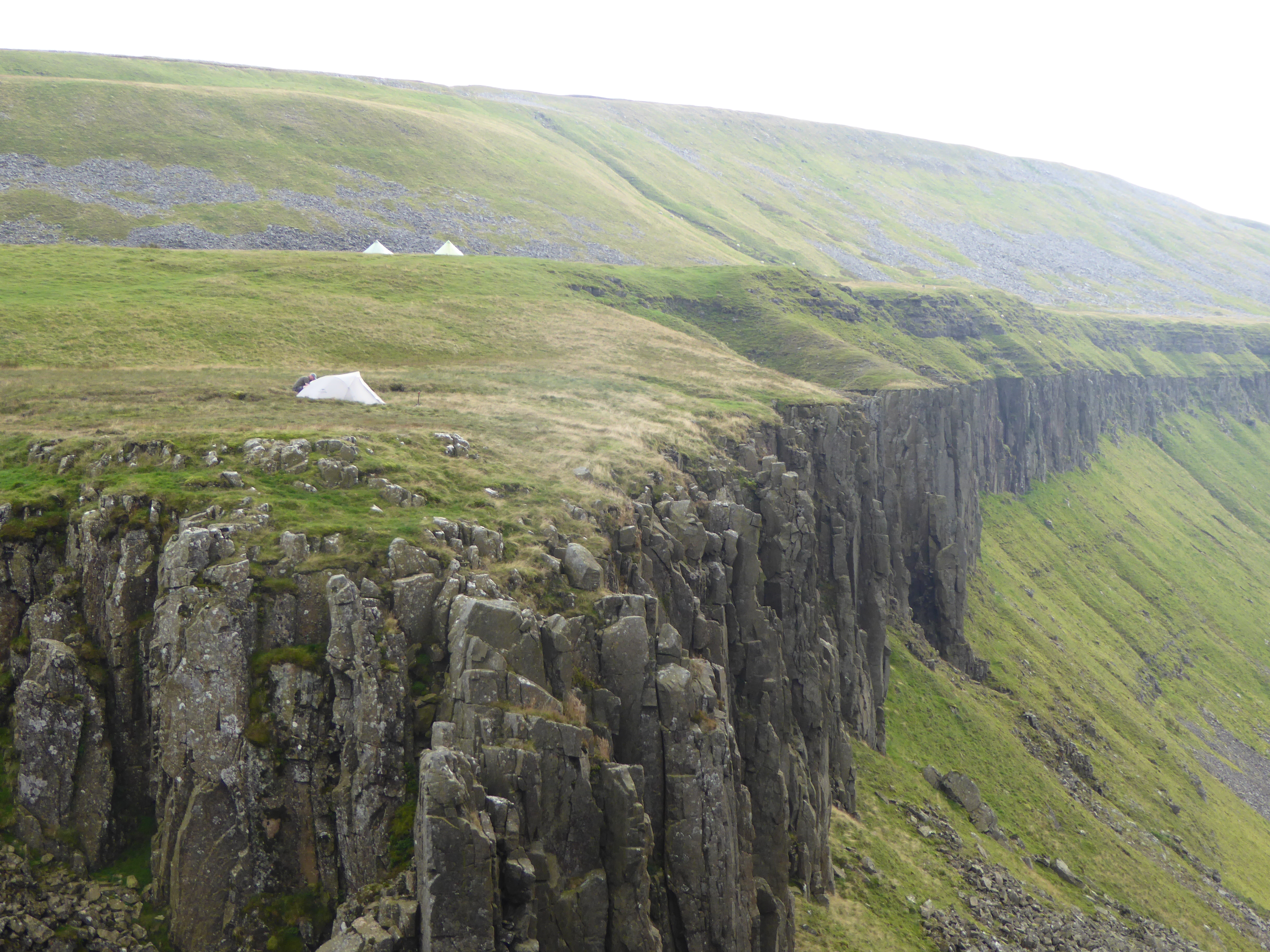
Our two tents are pitched on the shelf in the background above High Cup Nick


John getting up close to take photos


High Cup Nick

Day 11 High Cup Nick to Garrigill

31.3km, 1090 metres of ascent, 10 hours 30 minutes

The morning after the night before

…it was horrid. Clag, wet and windy. Not a sign of High Cup Nick. It must have been stolen overnight. We had to lose a great deal of height before we were out of the cloud but were in Dufton by 9.15am. The café didn’t open until 10. As we stood outside ready to break open a snack the owner arrived to set up. I put on a very sad face and shivered a bit and so she let us in and kindly had bacon and sausages sizzling in the pan within minutes. 

The rest of the day, for me, was a tiring slog. We ascended into the cloud again as we made the long climb up towards Knock Old Man and then stayed in this foulness for several hours, with the wind becoming increasingly fierce as we crossed much featureless ground. By the summit of Great Dun Fell the wind was gusting, I guess, to gale force. We plodded on over Little Dun Fell and on to the summit of Cross Fell, the highest point in the Pennines, at just under 3000 feet above seal level. No views, of course. The experience at the top was almost surreal. We arrived just before a large party who had walked up from Kirkland. They were all Christians on an annual pilgrimage in honour of some allegedly well known historical Christian figure with associations to Kirkland. Not well known enough, though, for me to have heard of him. The conversation around us in the wind shelter became increasingly bizarre as well as intense and philosophical as theology was discussed by the group, in between musings about Manchester United’s chances that afternoon as at least one of them was a fervent supporter.

The summit of Cross Fell


Looking surprisingly chipper on the summit of Cross Fell

We headed onwards and downwards. The plan had been to wild camp by Greg’s Hut, the bothy on the side of Cross Fell, or just beyond. I can’t quite remember why we didn’t. I know we weren’t keen on staying in the bothy as it was a Saturday and we expected it could be busy. As we walked on it became increasingly clear that we weren’t going to find a decent camp spot. Plan B was to get to Garrigill where camping at the village hall is possible. This added 10km to our planned day, really too much for me but I tried to be a brave little soldier. In Garrigill we asked a lady dressed up in a party frock where the hall was. She pointed it out, mentioning that the 'do' there that evening was to mark the christening of her son. The caretaker came over with us to show us where to pitch, how to pay the modest fee (“just pop it in the honesty box”), and gave us the combination code to the locks on the hall so we could use the showers, toilets and kitchen.

Camped at the back of the Village Hall in Garrigill

We pitched at the back of the hall as instructed, with the children from the party playing on the swings by our tents and dads in their best suits standing around chatting and knocking back cans of lager. All very weird but very friendly. I was dog tired. It was late and we still had to cook. At least there were picnic tables near the tents so we would have more than the usual levels of comfort.

John speculated. “I’ll bet there's far too much food in the Hall,” he said. At that very moment the lady whose party it was appeared at the tents. “We’ve got far too much food in there”, she said, and handed us a plate of sandwiches, rolls, pizza slices and cakes. No need to cook. A few minutes later trifles appeared. I went inside to thank the lady doing the catering. “Ooo you’ve not had coffee yet”, she said, “or would you prefer tea?” The people of Garrigill are wonderful. As is their village hall for camping. Do remember this if you are in the area.


Day 12 Garrigill to Knarsdale

18.6km, 325 metres of ascent, 6 hours 45 minutes (including a very long stop in Alston)

The South Tyne Valley near Garrigill

The weather was fine again. The walk to Alston, following the South Tyne River, was pleasant. Alston’s cafés did not appear to open on a Sunday but eventually we found one and also visited the Co-op and the Spar to fill our food bags. And pies may well have been purchased. In my case it was filled with black pudding and pork and lovely jelly stuff. Then it was off along the South Tyne again, with the Way making an uphill detour to walk by Whitley Roman Fort. Unspectacular walking, but not unpleasant and still dry underfoot. My theory is that if the Pennine Way was being devised today most of the route from Alston to Greenhead would change and it would follow the much newer South Tyne Trail along the old railway line to Haltwhistle then cut up to Hadrian’s Wall. But it doesn’t, although for one short 20 minute stretch as we neared Knarsdale, I did follow the South Tyne Trail whilst John, being a good boy and a purist, headed up some fields and then back down again along the Way proper.


This is that old railway viaduct that's always photographed on this stretch of the Way, possibly because so few features stand out


Snack stop by the South Tyne

The plan was to camp at Stone Hall Farm at Knarsdale. We arrived. The farmer’s wife explained that they hadn’t done camping for two years, “too much hassle since Covid” apparently. This would mean walking on and trying to find a wild camp spot. I did my best to look tired and generally pathetic. Not difficult. I think I even managed to make my bottom lip start to wobble like a small child who has been told that he can’t have any sweets. It worked. She pointed to a field we could camp in and took us to the outside tap to fill up our water bottles. More kindness.

We spent the late afternoon playing ‘What time is it Mr Wolf’ with the large numbers of sheep in the field. They stood in a long line watching us at the tents. Each time we looked away they moved a little closer. We would look round and the line of sheep would be standing still, only closer, watching us. We would turn our backs. Repeat. They got closer and closer. Eventually they would run off. A few minutes later they would do it all over again. Well it must be dull being a sheep in Knarsdale.

If you look pathetic enough you can blag a spot in a friendly farmer's field


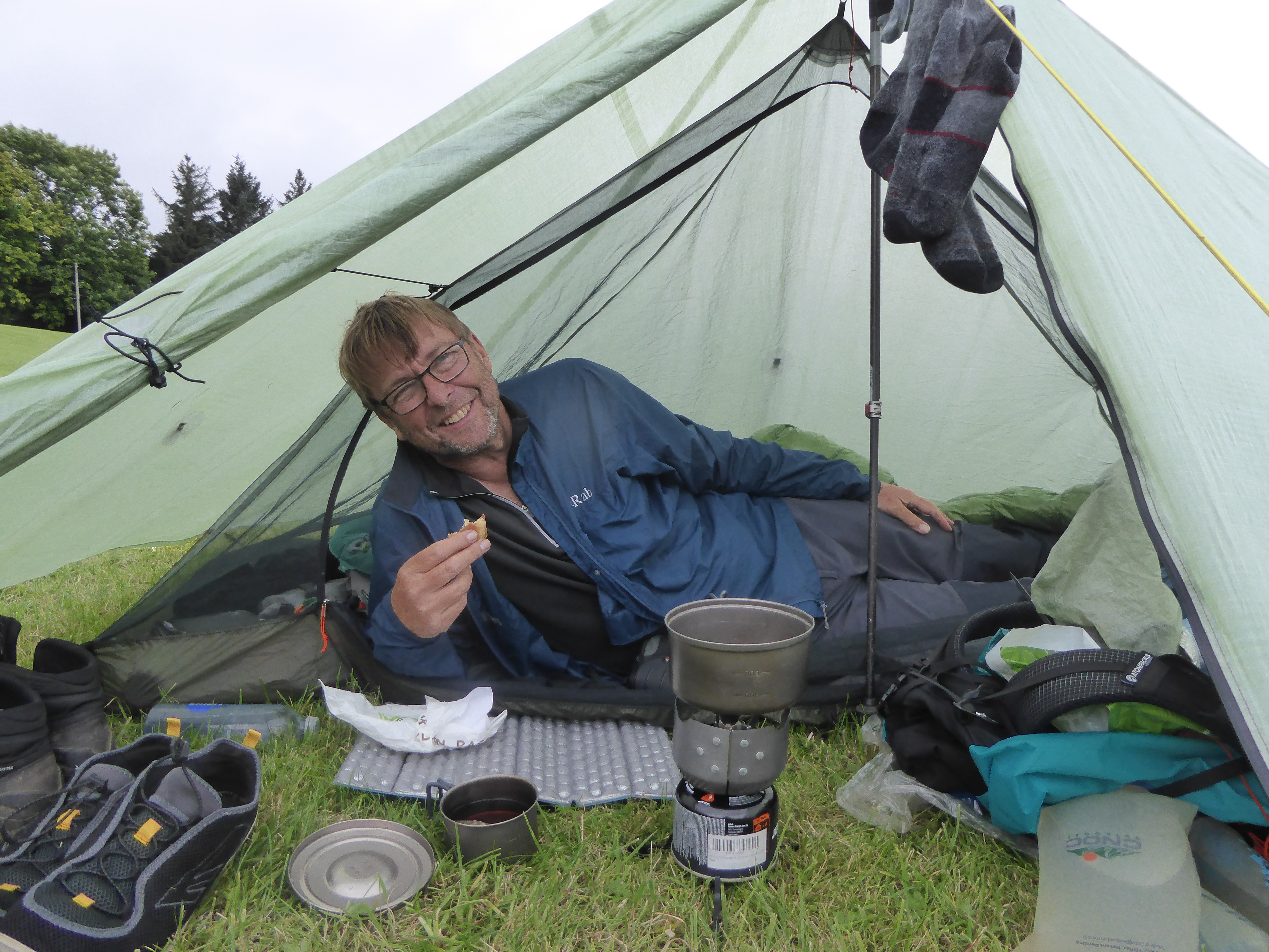
Happy bunny eating the last of his black pudding pork pie


Wednesday 20 October 2021

Pennine Way, Days 5 to 8 Gargrave to Deepdale: Sunshine, dehydration and a good sit down

Day 5 Gargrave to Fountain's Fell

22.5km, 794 metres ascent, 7 hours 40 minutes

Malham Cove

Now listen. Well you can't actually listen because I'm not really speaking, but in my head I'm talking to you. If you have never walked the Pennine Way and fancy doing so, but you do not think you can manage the whole thing, you may like to try heading north for a few days from Gargrave. This section is wonderful. The best. Simply the best. You leave the village and head off through gorgeous fields, yes lowland scenery, but still northern England at its picture postcard best. Eventually you will follow the River Aire to Malham in the knowledge that when you get there you still have much more to come.

And the best is not even the availability of rolls filled with pork and poultry products at one of Malham’s cafes, although John and I arrived there at mid-morning, a civilised time to drink pots of tea and replenish ourselves with egg and bacon and sausage filled rolls. Furthermore, the sun was out. Big time. It was getting really warm. I wished I’d donned shorts and a thinner shirt but being over warm was a small price to pay.


I'm enjoying this

We joined the Sunday day tripper crowds on the walk from the village towards Malham Cove to take similar pictures to those that have appeared in every Geography O Level or GCSE text book that has ever been published. Upland limestone scenery. Or ‘karst scenery’ if you are German and reading this (are you Nathalie?).

John bounded up the steep rock steps that make up the path to the top of the cove. I half bounded up them and then it was into more limestone loveliness as we walked through the impressive dry valley by Ing Scar crags and on to Malham Tarn. Despite setting off carrying a large amount of water I was already starting to get dehydrated thanks to the heat and the steep climbs but there was an ice cream van selling cans of pop and then we lazed on the grass by the tarn and ate lunch and popped Ibuprofen for aching shoulders.


John on the limestone pavement above Malham Cove


Looking back along the Pennine Way in Ing Scar

We came to Tennant Gill and filled water bottles, not just for the rest of the day but for overnight and the morning. All the smaller streams were dry and we knew we’d find no more until well in to the following day. I drank over a litre at the stream and collected another four litres of the stuff and it still wouldn’t be enough. John has a different technique to me when it comes to fluid intake. I am constantly sipping the stuff; he has the habits of a camel and can go hours, indeed, almost all day, without a drink and then fills up like a ship of the desert when the opportunity arises.

Our substantially increased loads were then lugged up the last couple of kilometres as we climbed to a superb wild camping pitch, just after the Way’s Fountain Fell high spot. The weather was perfect for a lazy late Sunday afternoon and evening, with views over to Pen-y-ghent and far beyond. This had been the best day so far and, in retrospect, for me was probably the best of the whole walk.


Fountain's Fell wild camp: one of the best


Day 6 Fountain’s Fell to Cold Keld Gate

24.6km, 779 metres of ascent, 8 hours 35 minutes

The day started murky. Pen-y-ghent loomed, looking ominous. As you walk towards it your eyes are drawn to its steep southern edge which dominates the sky line, and which you are going to have to climb. If you have never climbed Pen-y-ghent, and I hadn’t, you can be assured that it’s true what almost everyone who has been up that route says. It is nowhere near as bad as it looks. The last hundred metres or so is a steep, but easyish, rocky scramble, although as I have aged, and my leg muscles have become more feeble, I find some of the bigger step ups when wearing a full pack lead to my knees seeing far more contact with the rock than they once would have done. Not elegant but it gets me there with a few anxious moments and a little huffing and puffing. John, however, seems to glide over such minor obstacles in a way I never could have done, even 30 years ago. Anyway, we were at the top 75 minutes after starting out.


Pen-y-ghent: short, steep but sweet


Trying not to look a little tired at the summit of Pen-y-ghent...


...whereas John didn't have to try

Horton-in-Ribblesdale followed an hour or so later. No cafés there now since the once legendary Pen-y-ghent café shut down. Another lockdown casualty? We were reduced to eating cereal bars and M and Ms and stuff on the pavement when what we really needed was a sit down with rolls filled with sausage, bacon and egg, smothered in tomato ketchup and washed down by lashings of strong English Breakfast. However, we were brave little soldiers and didn’t complain.


The Way is generally reasonably well signed, although as always these things are least in evidence in some of the places where they are most needed


We continued north across the limestone, passing pot holes, sink holes and more limestone pavement. Ling Gill Bridge saw us at the last place we were confident we could get water for the rest of the day and for dinner, overnight, breakfast and the walk on to Hawes. We filled up and loins were girded to carry the extra weight for the next 6km, heading up to the Cam Road which is now a fairly unpleasant long, straight, badly surfaced high level track used by forestry vehicles. It’s a bit of a trudge but hey ho. Our decision to lug the water proved to be the right one, as the couple of springs and small streams shown further along on the map were all dry. At Kidson Gate John raced up and down, backwards and forwards next to a dry stone wall and after some poking around returned in triumph carrying two gas cartridges that he had hidden a couple of weeks earlier. Our plan had been to camp at Kidson Gate or a little further along the track towards Hawes. I was pretty done in by now so stood around uselessly whilst John bounded up the hillside to check out likely spots for our tents, but with no joy. Fortunately, we’d noticed a couple of possible pitches a few minutes back along the Cam Road so doubled back to Cold Keld Gate and found two pretty decent Duomid sized pieces of level ground just off the Pennine Bridleway. Result!

Red Moss Pot (I think)


Ling Gill Bridge: The last stream running so we carried water from here for our overnight camp 6km further on


Cold Keld Gate wild camp


The view from my sleeping bag as the sun went down


John on sunset watch

Day 7 Cold Keld Gate to Usha Gap Camp Site

25.1km, 618 metres ascent, 9 hours


Lovely Hawes: Pies and other pork products were purchased in bulk

It was just a couple of hours to Hawes from Cold Keld Gate so we were in town by 9.30am. John, obviously craving pork products, headed straight for an excellent butchers (or was it a bakery?) that he knew. Whatever, it sold pies full of the stuff. Other meats were also available. We then headed to various other shops including the supermarket. Supermarket? Not in quaint Hawes. That’s a grandiose term for the Spar. We then did what the majority of backpackers do after a week of calorie deficit. We bought too much food. I was still eating flapjack from here over a week later in Kirk Yetholm and it was just as delicious then.

Still craving food and fluids we sat in the sun outside a café and had more pork filled rolls. Sadly, the sausages tasted like they had been grilled each day for a week before being served up to us, but we didn’t care – we had pies in our packs for later.

Through the fields to Hardraw

The walk over the fields to Hardraw provided more Dales loveliness with the added bonus of hardly any uppity bits. But then there was a very long drawn out uppity bit, Great Shunner Fell, which was delightful despite the hot sun, and despite the uppityness and the drawn outness.

Now John had spent a week walking at my pace with no outward sign of irritation and, indeed, he seemed remarkably chilled about this. I couldn’t have shown such patience with a companion. Feeling guilty about this when we were a kilometre or so from the top, I removed the hobbles I’d tied to his legs, unfastened the lead from the choke chain around his neck and told him to go on ahead, asking him to time his arrival at the summit and then to note mine. Which he did. I cannot recall the exact results of this experiment but seem to remember that I had in advance reckoned his pace to be at least 50% faster than mine and this seemed to be proved about right. In fact I suspect he was still, by his standards, dawdling as he climbed upwards.

I hadn’t waited until the summit to start consuming pie but still had some left when I arrived and we both lay on the grass in the sun, propped up against our packs, eating pies and generally loving the day.


At the summit of Great Shunner Fell
I inherited my shorts from Eric Morecambe. John didn't.
(Mine are the Montane 'Razor' model. It should be said that they are extremely light and comfortable and recommended to anybody who doesn't care if they look like a complete pillock)


Heading for Thwaite after Great Shunner Fell 

Later we headed down to Thwaite, 6 km in hot sun with little water left but where we found the Kearton Hotel-café-cum-bar open. Smiley face emoji. Beer glass emoji.

After the rehydration exercise (it was tough but had to be done) we left the Pennine Way for a kilometre or so and headed to Usha Gap camp site near Muker. It provides a superb stopover for backpackers. A shop, excellent showers, laundry, drying room, secure lockers with phone chargers, flat pitches and all for £8 per head. Use it if you are in the area. 

A badly needed rehydration stop in Thwaite before the last kilometre to the camp site


Through the fields to Usha Gap


Usha Gap camp site: Highly recommended, great facilities, great value, great place to clean up and recharge

Day 8 Usha Gap to Deepdale Beck

24.5km, 688 metres ascent, 8 hours 50 minutes

This was the day we left the Dales of Yorkshire and crossed into the Dales of County Durham with their wilder and more remote feel. The two significant landmarks today were to be the Tan Hill Inn and then God’s Bridge and the halfway point of the Pennine Way just before crossing the A66.

Yorkshire Dales scenery: looking back as we headed towards County Durham


Approaching Tan Hill

Tan Hill is the highest pub in England and so attracts visitors from far and wide. We arrived and sat outside in the sun but also in a fierce wind. It has to be said that whilst the inside of the pub has some charm the outside seating areas are now quite awful, regimented rows of tables in what feels like it could otherwise have been a rough gravel covered car park.

I bought the first round. John, who clearly cannot take his beer in the morning went to get his round in and managed to stumble on a step causing a potential disaster as the sole of his boot came away at the toe. These were almost brand new boots, purchased not long before our trip. And on examination he found that his other boot had also developed a split, nothing to do with his single pint of beer fuelled slip. Gaffer tape was applied as a temporary fix but we still had about 140 miles and 9 more days of walking. We spent much of the rest of our stop at the pub discussing potential contingency plans in the belief that the next shop that might sell new boots was in Alston, four days away. Courier a pair up from home? Further temporary repairs with materials to be bought the following day in Middleton to get us to Alston? Hope for the best?


See that step in the background? That came close to causing us a major problem. That and John being unable to hold his beer

Sleigtholme Moor. Miles of it. A featureless, boggy nightmare, apparently, in wet conditions. Fortunately, we had had a dry summer and it was merely a little dull. And featureless. Did I mention that? Our navigation went a little astray after the worst of the moor was over. This was because I was lovingly explaining my 35 year career in public service to John in fascinating detail and John was too engrossed by my tales of why the public sector was all the better for my presence and had lost true genius when I retired to look at the map. I had just got to 1987 when we spotted our mistake, but could rectify it before too much distance damage had been done. We headed on to God’s Bridge, and soon after to the half-way marker on which some wag has scrawled the witty remark “suckers” aimed at Pennine Way through hikers. Possibly we are, but I know whose life I would rather be living and it’s not that of the pathetic prat with the permanent felt tip pen who probably spends his life watching box sets on Netflix.

Sleightholme Moor
(Yes it is as dull as it looks, but at least it was pretty dry when we crossed it)


The stream at God's Bridge

135 miles down. Half Way! The tunnel under the A66

Deepdale Beck was our intended camp spot and we had rightly assumed it would be substantial enough to have water in it. Better still it had a walkers’ shelter, so credit to the estate which provides it. And the shelter has chairs in it. So we borrowed a couple and luxuriated on them as we cooked evening meals before having to hide behind the midge nets in our inners as the bitey things came out to end our evening in the sun.

Wild camp by the shooting hut and walkers' shelter at Deepdale Beck


Luxury. A proper sit down thanks to the chairs in the walkers' shelter