Showing posts with label Backpack. Show all posts

Friday, 7 September 2018

A Buttermere Backpack


Yup. They are orange. But at least he didn't wear the lime green pair

“Please let me come with you, David, oh please, go on let me.”

“No Geoffrey, and you know why.”

“But I like dressing up as a smurf, and that costume keeps my ears warm.”

“I said no, Geoffrey. You really showed me up when you wore it last time.  Those real backpackers were laughing at us when we had lunch on Thornthwaite Crag.  I have my reputation as a top fellsman to think of.  It took me almost 50 years of walking in the Lakes to earn that. It was destroyed in the course of one quick trail mix break.”

“Oh pretty please.  I promise I’ll dress soberly this time.  Oh go on.”

I gave in. There has to be some kindness amongst all the horridness in this modern world.  And did I make a single comment when he turned up wearing his orange Rab trousers?  I did not. My true nature shone through, as it always does. Sainthood cannot be many more years away.


Route for Day 1

The weather forecast was promising. The sun came out as we parked up in Buttermere and headed off along Crummock Water. A nice gentle start.  Forty-seven years of walking in the Lakes and I had never been along the delightful path along the western side of Crummock Water.  Picturesque, and with an added bonus, as the Kirkstile Inn is just beyond the end of the lake. We arrived at lunchtime, with half the day's distance but hardly any of the climbing done, and so we stuck to a single, non-alcoholic drink (and not even a single alcoholic one, in case you think I was being clever in the use of language there).

Looking back to Fleetwith Pike from Crummock Water
The path along Crummock Water
Happy Chappy at the Kirkstile Inn
After some loin girding on leaving the pub it was up through Holme Wood and along the beautifully engineered terrace path high above Loweswater, followed by a steep pull up the lower grassy slopes of Burnbank Fell and on and over Blake Fell and then down to hunt out a dry spot to camp in the col before Gavel Fell.

Loweswater and Holme Wood, with Grassmoor in the distance
On Burnbank Fell
I'm just starting to get that weary feeling in this picture
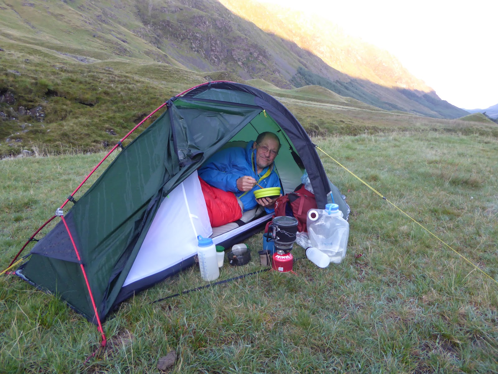
We were pitched by 4.30pm.  Geoff was soon in his chair and brewing up.  I have never seen anyone look as comfortable and relaxed when wild camping as Geoff is on a warm sunny evening.  For once I had decided not to have a freeze dried meal for my dinner but to cook properly – well as much as one can on a meths stove with one pot and no plate.  The less said about the meatball and baby wipes incident the better.  Suffice to say I have now washed all the affected clothing.


Geoff in his element

Just before sunrise on our second day

Temperature inversion over Crummock Water

The second day was tough.  It was only 13km and 828 metres of ascent but some of the climbs were fierce and the descents even worse.  It was also much hotter than we had anticipated, with brilliant sunshine for most of the day and little opportunity to top up our water bottles.  When I got home I checked my old logs and found that the last time I had walked the Red Pike – High Stile - High Crag – Seat ridge was in 2011.  Seven years has taken its toll on my fitness and ability, but it is absurd to complain.  It remains a superb walk with the most fabulous mountain scenery in all directions.
Fleetwith Pike from near High Crag
Grey Crag looked superb.  Had I really hauled a heavy rucksack of climbing gear up to it from the valley floor one hot day in 1996 for several hours of climbing on its traditional rock routes?  I had.  No way could I ever do that these days.  The descent of Gamlin End was as horrid as I remembered, but at least I knew it would be bad, so had reconciled myself in advance to a few minutes of purgatory.  But beyond Seat and Scarth Pass the going down to Ennerdale was fine, and the brew at the Black Sail Hut even better.  After this Geoff picked out a splendid camp spot a little higher up the valley for another evening of sunshine.

Glorious pitch in Upper Ennerdale, with Great Gable and Windy Gap on the skyline


From my early morning walk with Mr Trowel

Breakfast

The Black Sail Hut

Warnscale Bottom and surrounding Fells

The head of beautiful Buttermere


Rain had been forecast for our final day but our luck held.  There were a couple of showers in the night but none as we made our way up to Scarth Gap and then down to the lovely Buttermere shoreline.  It was an easy finish to a superb three days with excellent company. Thanks as ever, Geoff.  And you know that the insults are because I am really secretly jealous of your sartorial elegance in the hills. 😄
Route Days 2 and 3 - with various bits missing as I struggled with the screen shot

Friday, 22 September 2017

Backpacking Sextagenarians

Well Geoff has pretty much told the story of our recent five day walk across the Lakes. And with remarkably few embellishments, and even fewer jibes at his inept companion.  He had endless scope for these, but chose not to indulge. Thus, my inability to put up a tent with his lightening speed, or to achieve the Holy Grail of drum tight silnylon to stop endless flapping in the breeze, hardly figured in his account. Several dodgy photographs he took were not used in his post.  So having no excuse to poke fun at this kindly old chap I shall keep to the facts, with some passing comments on my thoughts about backpacking at the start of my seventh decade. 

Geoff has also posted maps of our route, so I will not bother. I had originally hoped to do a much longer walk but various domestic commitments reduced the time I had available. As it happened five days was plenty, given my fitness level.

I'm not sure whether I'm proud to say that I am now entitled to own a Senior Railcard, but I flourished it at the ticket clerk at Penrith Station, gave Geoff a lesson on the need to push the button on the outside of the carriage to open the train door, and our journey began. Two sextagenarians setting off to zig-zag their way to Keswick from Windermere over five or six days. Six if we were feeling fit and full of life, and fancied a diversion to Buttermere.  Five if the organiser of the trip ie Lanky Old Fellbound was feeling radgered and fancied a gentle end to the stroll along the shores of Derwent water.

And we were off
Within an hour or so of starting I forced Geoff up Sour Howes and Sallows. It was only then that I realised that he has no understanding or empathy with peak bagging. Nor have I these days. To a point. But these unremarkable hills are two that I have only climbed once; and as my unintended second round of the Wainwrights is almost complete, it felt like they had to be done whilst we were passing.  I'd worried that the ground above the Garburn Pass would be boggy, and finding a decent spot to camp problematic, but we had little bother on the lower slopes of Yoke, and we finished our first shortish day nice and early in glorious sunshine but a cold, stiff breeze.
First wild camp. Lower slopes of Yoke


Gratuitous "look at the fabulous view from the tent whilst I'm brewing up" photo

Day 2, and there were eight Wainwrights between us and our intended camp spot high above Angle Tarn. Well actually only five were in the way, but the other three (Kidsty Pike, Rampsgill Head and Knott) were so close to our route that we did them anyway.  We'd got to the fabulous beacon on the top of Thornthwaite Crag before I realised that not only had Geoff no intention of setting up a spreadsheet, or at least a tick list, to record his progress at completing Wanwrights, but also that he had no idea how to pose on the top of a hill. He'll be telling me he doesn't own any cuben fibre gear next, I thought, but then dismissed that notion as ridiculous.

On Froswick. Fix the Fells remains on course to urbanise the Lakes.

Striking a jaunty pose on Thornthwaite Crag

Clearing clag and rain. Looking back to High Street from near Kidsty Pike
As we headed up the last pull of the day to escape the over-popular camping spots at the tarn we agreed without speaking that the top of Angle Tarn Pikes could wait for the following day, despite camping within five or ten minutes of the top. We was well done in we was.
Camped on Angle Tarn Pikes, at the end of a long Day 2

The best dehydrated meal I've ever had
I woke early. I always wake early. Five-ish if I'm lucky. Two-ish on a bad day. I brew up and get going slowly.  As I have aged and lost flexibility I do find being in a tent can be hard work, exacerbated by my unnatural height. Backpacking tents are not designed for lanky gits. I do a task, such as heating up water for my breakfast oats, then lie back and recover for a minute or so before taking on the next task. Eating them. Then the next.  That might involve, say, lassoing my feet one at a time with my trousers or socks to get dressed.  Or packing up a dry bag. Then realising just as I have done that thing with squeezing the air out and fastening the roll top that I have left something out and thus need to repeat the process.  So after about two hours I'm ready for a lie down again but it will be time to get my boots on.  I'm seriously thinking of taking a shoe horn on my next trip. Putting on my boots whilst lying on my side or sitting in the tent door way seems absurdly hard. Then I am ready to get the tent down and packed up. I'm sure it was all much easier when I was twenty.
Early morning brew, Day 3

Today, fortunately, is to be an easy day. The easiest of the trip. With a break in Glenridding for cake. And possibly bacon. But certainly cake. I try to smile at all the Americans, and the many others doing the Coast-to-Coast. We are walking against their flow. "No, we aren't going the wrong way. No, we aren't doing it. No we haven't come all the way from Shap by ten in the morning."

Now I would like you to compare and contrast the next two photographs.  Ideally, I would have placed them next to each other, but my ability to manipulate Google Blogger is limited. It is true that Geoff may have much better IT skills than me and he can prettify his blog very nicely. He fails miserably, however, in the posing on top of hills department.  He really needs to team up with Alan Sloman for a day or so in the mountains. He would then learn the art pretty quickly, or face the backpacking equivalent of the Wrath of Kahn.  You will note that the top photograph is of an upright, rugged, rufty tufty but veryveryniceman.  The second appears to be a chap broken by a string of Wainwrights and the ranting of his walking companion. Someone who will lie on the ground and scream and scream if he hears one more complaint about Fix the Fells and its inept handiwork.

A fine figure of a man who has just bounded up Angle Tarn Pikes

A broken man, resigning himself to defeat in the posing on top of a hill competition. Never mind, Geoff, you will improve with practice.
After Glenridding we plod up Grisedale.  It rains heavily for a while. The wind gets up again and the temperature drops.  I had been reticent about stopping here but it was the natural place on our route.  We find a reasonable spot below the tarn.  Other tents are on its shores. Six more backpackers arrive and set up a hundred yards from us.  Fortunately they are quiet.  But camping at Grisedale Tarn is not a good experience.  It is over used , as are many of the tarns in the lakes, but this is one of the worst.  Rotting toilet paper and worse lie around.  Two broken beer bottles are poking out of a bog.  It goes against the grain, but I do wonder if regulation is needed.  At the least the National Park should start encouraging people to pack out toilet waste.  I know only the responsible would do it, but at least this would mean less mess in these areas, and less environmental damage. I don't know the answer really.

The impact of the over popularity of the Lakes saddens me, even knowing I am part of the problem. The erosion, the terrible path repairs, the litter, the mess at tarns such as this. I am glad I knew the area forty-five years ago, when these problems were much less.  I feel like a man in the wrong era these days. Apart from when I'm ill and want modern health care of course.
Ready for the third night out. Pitched on layers of used rotting toilet paper, tampons and broken beer bottles below Grisedale Tarn. A case for some form of regulation?  
The fourth day turns out to be far tougher than I had planned, despite following our route to the letter. Three more lowlyish Wainrights, but a reasonable distance and lots of ups and downs.  I have a difficult hour or so after Helm Crag. My legs lose all their power and turn to jelly.  I am physically shaky.  I put it down to dehydration, so we stop to filter water from a small pool. It works and I rapidly feel much better. But it's another long day. Fortunately with a camp site and a few pints and a steak in the very good Langstrath Country Inn at Stonethwaite. 
A sunny Sunday on Helm Crag above Grasmere. Generally, though, it was pretty quiet and we still found solitude for much of the walk

Rock gymnasts on the Howitzer, Helm Crag. I did it once to say I had. No need to repeat.

Looking east from the pull up to Greenup Edge

Looking back to Lining Crag having just descended a Fix the Fells staircase
The fifth day of walking. A gentle eight or nine mile day into Keswick. Still several hours, but little in the way of serious climbing as we follow the Cumbria Way along the River Derwent.  I bore Geoff with details of the ash scattering that my nearest and dearest will have to undertake for me by this river at sometime in the future.  We eat the best ever breakfast rolls at the cafe in Grange. Then it's Keswick.  My favourite town in the whole world.  The route being perfectly planned we get to the stop just fifteen minutes before the Penrith bus.

It had been a super trip with excellent company. But I was ready for a shower and a rest. 
Well it would have been rude not to go in. Grange-in-Borrowdale.

Sunday, 25 June 2017

Fellbound's Tour in the Lakes Michaelmastide 2017


Many years ago I received as a gift a coffee table book, 'Wainwright's Tour in the Lake District, Whitsuntide 1931'.


The book describes a week long circular tour of the Lake District, devised by Mr Alfred Misogynist-Miseryguts himself. He planned to do the walk with some of his pals from Blackburn, staying at farmhouses and bed and breakfasts en route. Not that Wainwright would have used the expression 'en route'. Not keen on foreigners was Alf. Never went abroad, if you discount Yorkshire that is, and never ate foreign food.  As it happened, his plan was too ambitious for them and they never completed the walk. The book may no longer be in print, but I see that it is available second hand on Amazon from just a couple of quid. It's worth a look, not least to see his marvelously written handwritten plans of the route.

As a Lake District obsessive I have, for many years, thought it would be a good thing to do something similar. Thus, I have recently sketched out a 10 day circular backpack of the Lakes, which I fancy doing later this year. I describe it below, and welcome any comments and suggestions for improvement from readers who know the Lake District well.

In passing, it is worth commenting that despite the oft mentioned compactness of the Lake District, my 10 day itinerary hardly scratches the map, and leaves many wonderful parts completely untouched, including the entire Northern Fells, much of the central area and so on. However, having climbed all 214 of the Wainwrights at least once, almost all twice, and some 20 times or more, I am happy to limit my ambitions for the walk. It does not need to be a peak bagging exercise.

Fellbound's Tour of the Lake District, Michaelmastide 2017
Some larger scale maps of the route feature at the bottom of this post, together with a table showing distances and so on. The plan is to tackle the walk this Autumn if I can create the space in my diary. This is rather tight for reasons too boring to mention. I hope to camp out every night, mainly wild camps, but staying on a few commercial campsites when necessary. If the full 10 days is not available then I have an option of doing a semi-circular trek from Windermere to Keswick taking either 3 or 7 days, depending on whether I take the clockwise or anti-clockwise version of the full route.

When I finished my initial sketch of the route my first concern became the lack of resupply points on the western section -  potentially requiring seven days of food to be carried, something which I am not really prepared to do. A possible solution is to send a food parcel to the camp site at Boot if the manager there is prepared to allow this. I have not mapped out foul weather alternative days, but a quick look at the map suggests that these are easily available for each day that my main plan takes me up high.

Day
Route
KM
Ascent (m)
Est Time
Hills


1
Windermere to Baystones / Wansfell Pike
10.4
598
4h 35m
Baystones (poss add Sour Howes and Sallows


2
Baystones to Greenburn Beck
14.7
599
5h 40m
None


3
Greenburn Beck to Boot
22
1176
9h 25m
Great Carrs, Swirl How, Old Man, Dow Crag etc


4
Boot to Wasdale Head
15.4
838
6h 40m
Irton Fell, Whin Rigg, Illgill Head


5
Wasdale Head to nr Starling Dodd
13.6
1349
7h 55m
High Crag, High Stile, Red Pike


6
Starling Dodd to Grasmoor
15.2
1148
7h 40m
Great Borne, Whiteless Pike, Wandope, Grasmoor


7
Grasmoor to Keswick
13.5
471
4h 55m
Eel Crag, Sail, Outerside, Barrow


8
Keswick to nr Watson’s Dodd
14.6
1033
7h 05m
Clough Head, Great Dodd, Watson’s Dodd


9
Watson’s Dodd to Brother’s Water
16.1
973
7h 15m
Stybarrow Dodd, Raise, Whiteside, Helvellyn, Nethermost Pike, Dollywagon Pike, Fairfield, Hart Crag


10
Brother’s Water to Windermere
19.1
854
7h 40m
Thornthwaite Beacon


I now have to sort out some dates to put this plan into fruition. I also need to arrange some decent weather and make plans for the dog, as I will not be taking him with me. Frankly, I do not want the extra weight that would entail, or the extra responsibility of looking after him, nor do I want to have to leave him outside the shops in Keswick or Ambleside when I am buying food.

And one final thought. A ten day backpack? Sounds like a good excuse to buy any new gear that I might possibly need. Happy smiley face, cheeky winky face.

Days 1 to 3
Day 4 and part day 5
Day 5 continued to part day 9
Day 9 continued and part day 10 (which finishes in Windermere)