Tuesday 16 November 2021

Pennine Way: Days 16 to 17: Selfishness or Chivalry?

Day 16 Byrness to Auchope Mountain Refuge Hut

29.6km, 1106 metres ascent, 9 hours 40 minutes

The Cheviots: great walking country

For those not too au fait (notice my linguistic skills there?) with the Pennine Way, the final stretch from Byrness to Kirk Yetholm can be somewhat problematic. It’s about 40km with a fair amount of climbing both up and along the Cheviots. Only very strong walkers can do it in a single day, but there is no settlement or accommodation along this high level section. If backpacking with a tent you are at an advantage here, although finding water can be an issue if it is warm and conditions are dry. Those without a tent have to drop down off the route and normally then need a lift to accommodation some distance away. John is more than capable of doing this section of the route in a long, single day. For me, though, this would have been completely out of the question, so we had planned two moderately short days of about 20km each, camping near the summit of Windy Gyle, the mid-point. As it happens this is not how things panned out.

Looking back after the climb through the forest

After a steep climb through the forest from Byrness the route opens out on to the broad, grassy slopes of the Cheviots, which makes for absolutely splendid walking, especially in the perfect weather we experienced  – a decent breeze, largely blue skies and a perfect temperature.

There was another package for Danielle pinned to a fence. We could see it contained a tube of Voltarol painkilling gel (this may actually have been spotted the day before – I’ve lost track). Soon after, at Chew Green Roman Camp, we dropped down from the route to the stream at the road head to take on water. It would be the last source until we were almost in Kirk Yetholm, over 25 hours away. And so an awful lot was needed with another 33km of walking and an overnight stop with dinner and breakfast to cook. Thus, I was to be burdened with another 4 litres and an extra 4kg to carry, with my camel like companion taking on slightly less. In fact, I would have liked rather more than this, as the day was getting warmer and I knew I would need to conserve what I had and would risk dehydration.

It had become apparent early on that our original plan of camping at Windy Gyle was not on. We would get there far too early, not least because we had left Byrness at 7.10 that morning. Furthermore, stopping at Windy Gyle would mean a much later arrival into Kirk Yetholm on the morrow (I really should have been born in Georgian times) which would make getting thither (see what I mean) in time to catch public transport home problematic. As it was we were at the top of Windy Gyle by 2.00 in the afternoon and so we pressed on. We thought that we might find somewhere nearer The Cheviot to camp, and I was hoping that I would feel fit enough to get beyond Auchope Cairn to the ‘second’ mountain refuge hut. This would mean a short final day and so an early finish.

Shelter cairn by the summit of Windy Gyle: A nice camp spot in calm conditions

The summit of Windy Gyle

The walking really was splendid, but by mid-afternoon I knew I was not drinking enough as I was trying to eke out my supply. I was also tired and getting slower and slower. John had every intention, and rightly so, of taking the spur to the top of The Cheviot; I knew that was beyond my physical abilities if we were to get to the mountain refuge to camp. Thus, after King’s Seat John went off ahead to climb The Cheviot, whilst I plodded on, increasingly slowly, up the steepish climb to Auchope Cairn and the even steeper drop down to the mountain refuge. John arrived there fifteen minutes or so after me, having walked at least a couple of miles further. It had been a fabulous walk but a pretty tough old day and I was feeling it.

Auchope Cairn

Looking to the Mountain Refuge Hut just to the left of centre in the mid-distance, (from the steep drop off Auchope Cairn)

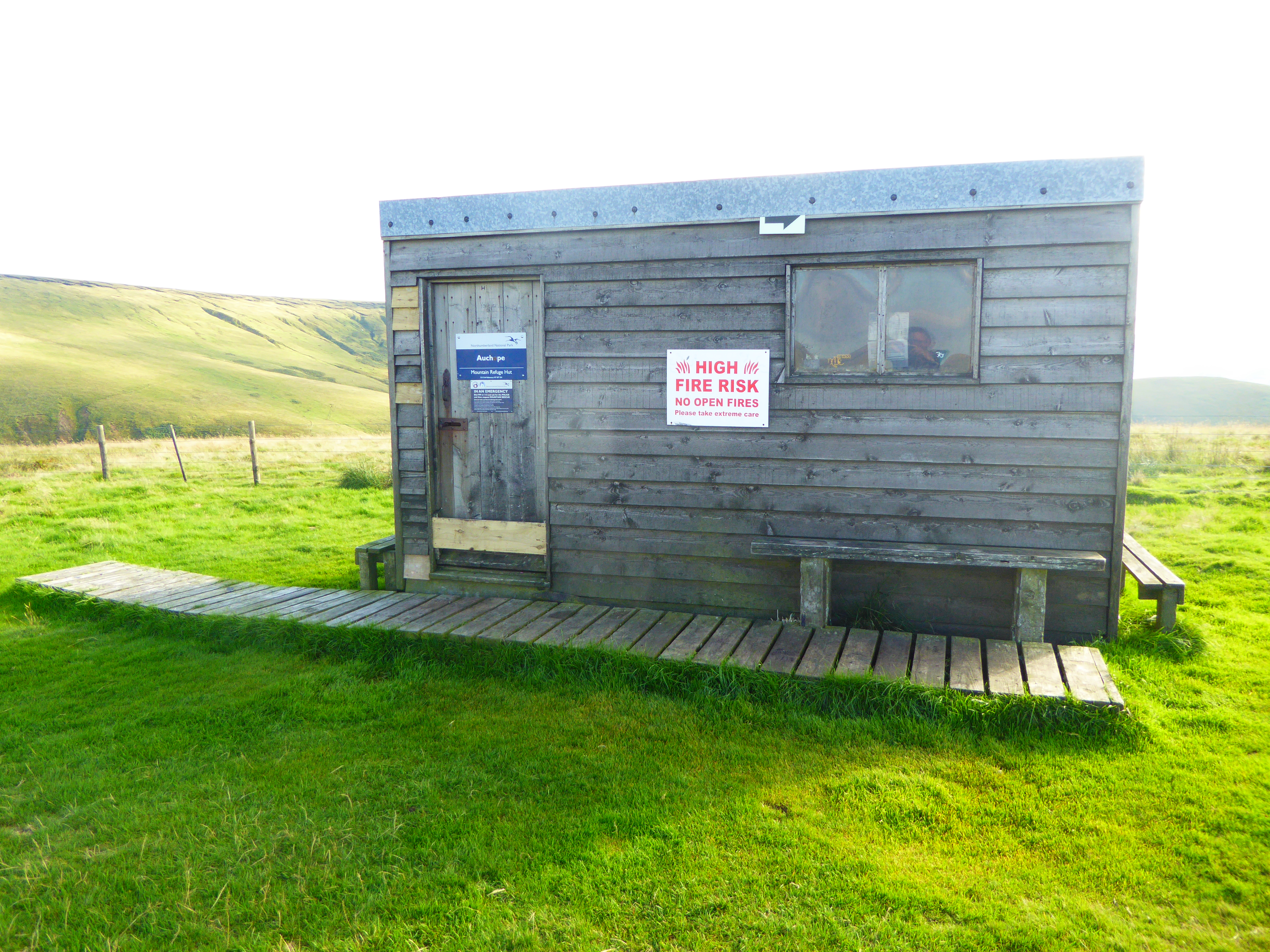
The Auchope Mountain Refuge

We pitched the Duomids at the front of the hut. Having been rationing my water all day I had calculated that I had enough for a couple of badly needed brews, with just enough left over to rehydrate my main meal and breakfast with a morning coffee, and a small amount for the morning’s 8 mile walk to Kirk Yetholm.

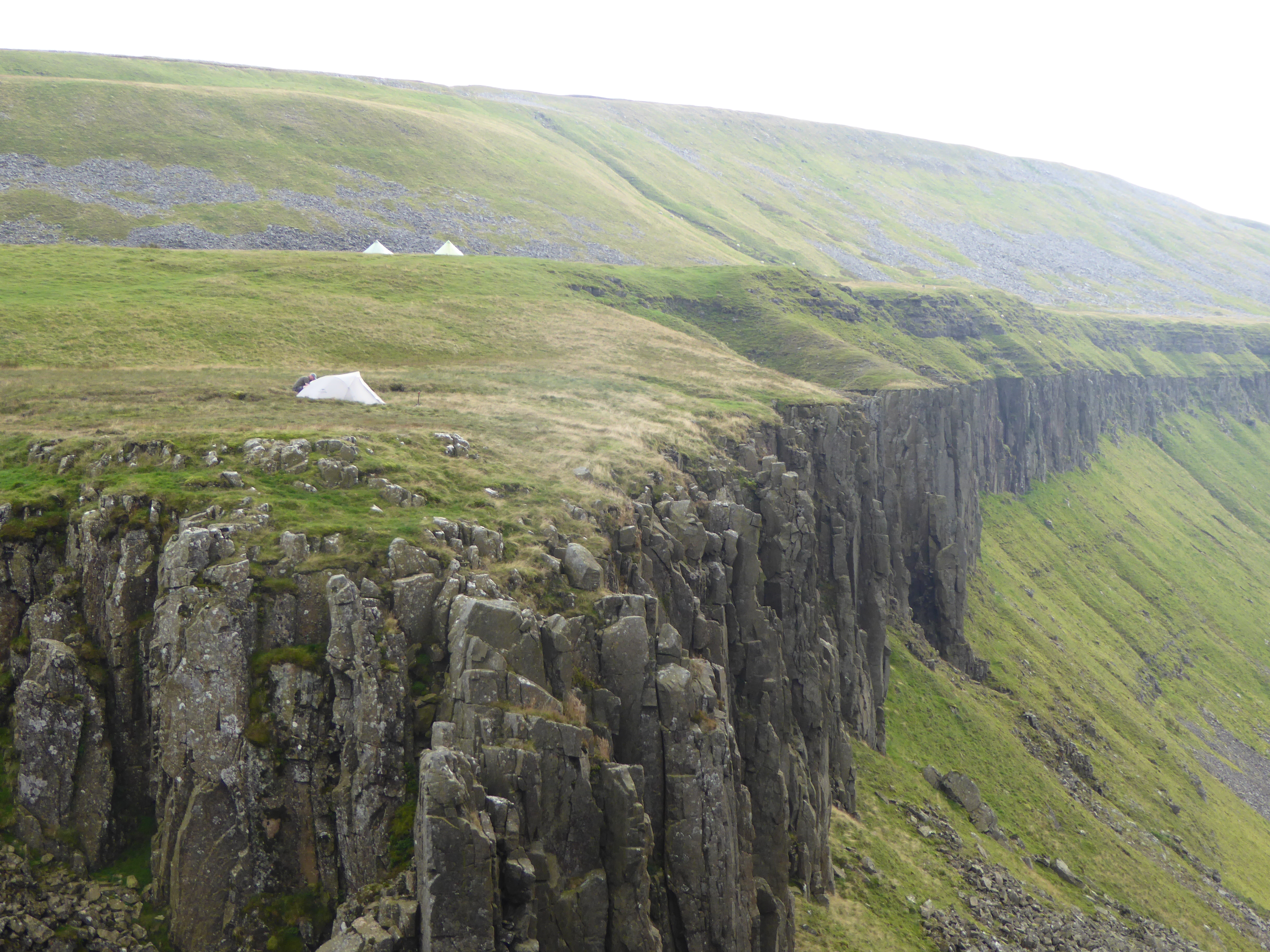
Our last camp of the trip. Super spot

Self-timed selfie: our final evening

Soon after the tents were up another backpacker arrived, walking the Pennine Way as part of a Land’s End to John O’Groats trek. She was a youngish woman (she turned out to be 31, although at first I had thought she was probably a student). Now. When you read what follows you might think it rather inappropriate, but bear with me, there is a reason which will become apparent in a paragraph or two. The woman was clad in shorts and a rather nice lacy sort of top that clearly hadn’t been made by RAB or Berghaus. She had long blonde hair, blue eyes, very long, tanned legs and a rather public school sort of accent. I did not, of course, notice any of that. Certainly not. Not at all. This was, as you may have guessed, Danielle (linky thing - yes alright the spelling's different. Don't get all pedantic with me).

The three of us sat in the refuge and had a brief chat, learning that the packages we had seen with her name on had been left for her by another through hiker she knew and whom (I'm back to the Georgian stuff, as nobody seems to use this fine word any longer) we had met several days before on both Great Shunner Fell and at Tan Hill. During this conversation I started to make 
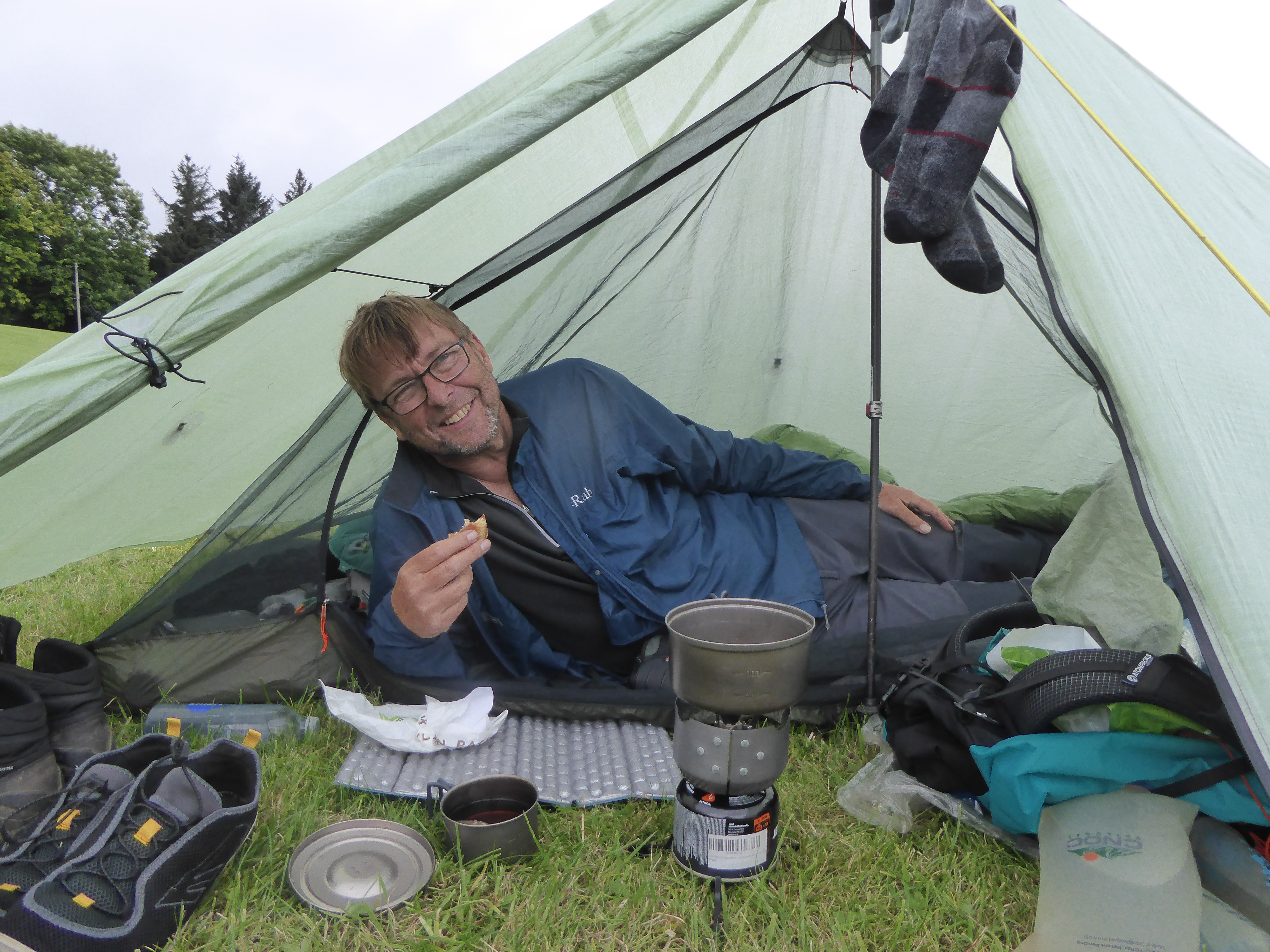
my desperately needed first brew, my stove set up on the bench in the hut. On my last legs with fatigue and thirst, I went to take my pot of boiling water off the stove and knocked the whole lot over onto the floor. A mugful of precious water wasted. My language was choice; really very choice. I apologised to John and Danielle whilst also just about avoiding bursting into tears of frustration and anger, but it was a close run thing.

Danielle offered us Jaffa Cakes. That was a different linky thing. Happy now? She explained that this was the only food she had with her. She had ditched everything else several day’s earlier to reduce the weight she was carrying. I think she had also abandoned her stove and pot. I may have misunderstood, but she seemed to be living off food handouts from people she was meeting en-route (I must stop lapsing into French in these posts). John and I were both carrying too much food so I offered her some cereal bars and John dug out a spare main meal. She then said she was very dehydrated as she had also decided not to carry water and didn't even have a water bottle, also to save weight, and she hadn’t drunk anything for several hours.

I guessed what was coming a minute or so before it happened.

“I don’t suppose you could spare me some water?” she asked.

Now. I am well into my sixties. I had been carrying a heavy pack for almost 10 hours and had made this task all the more difficult by adding 4 kg of water to my load and lugged this gradually diminishing precious cargo for 21km over the hills. I, too, was dehydrated and had less than I needed for the rest of our journey. But here was a damsel in distress. A tall, blonde, blue-eyed, shorts wearing, long tanned-legged damsel, not that I had noticed any of these things. Certainly not. Not at all. She looked straight at me and I almost said “yes I can spare some”. Then I thought. “Hold on, would you be saying 'yes' if this was a 6 foot bloke with a beard, who was less than half my age, fit enough to backpack from Land’s End to John O’Groats who had decided not to carry any water to save weight?” No I ****** would not. Not even if he'd been wearing shorts and had the looks of a Viking God.

Thus, there was only answer I could give. Selfishness trumped chivalry. As a result I had terrible feelings of guilt. Mind you, the subsequent mug of tea I made at my tent helped wash that nonsense away.

Day 17 (September 17th, 2021) Auchope Mountain Refuge Hut to Kirk Yetholm

11.5km, 390 metres ascent, 3 hours 20 minutes

Dawn over The Cheviot

It was a beautiful dawn. Click on the linky thing. Please do. Then chill out, relax and enjoy.

Did you like that? I did think of giving you a James Blunt track of a similar name but you’ve bothered to read my ramblings this far so why punish you even further? Oh go on then. I know you are closet fans of his. Admit it. especially you, Mad'n'Bad.

The Schil from the Mountain Refuge Hut

We were away by 7.15 am, and soon at the top of the last major hill of the route, the Schil. The wind was cold and we didn't linger. Then a long gradual descent, with the occasional sharp bursts of uppiness, largely along wonderful, easy grassy paths. It’s amazing how tiredness melts away after a long trek when the end is within reach.

Lovely 'striding out' country along the Scottish Border fence


Almost there

Then we were down in the valley again, and a kilometre of tarmac took us into Kirk Yetholm, the best part of an hour before the Border Inn was due to open. Photographs time. We’d done it. It was never in any doubt that John would finish. But for me? After my failure in 2019 I had been determined to complete the challenge this time but there is always doubt there. Fortunately that hadn’t surfaced during the 17 days on the trail, not least because I was with John. Ultra-competent, great navigation skills, fit and experienced. All those things, but above all patient, fun, supportive and great company. I doubt I would have completed the walk without him there. But I did. And I think again of how I ended my blog posts in 2019 when I had packed in my attempt to walk the Pennine Way after just 4 days. Yep. I’d done it. So like me, don’t forget. When you get so down that you can't get up, and you want so much, but you're all out of luck just Hold on Tight to your dreams. And that's the best linky thing of all.


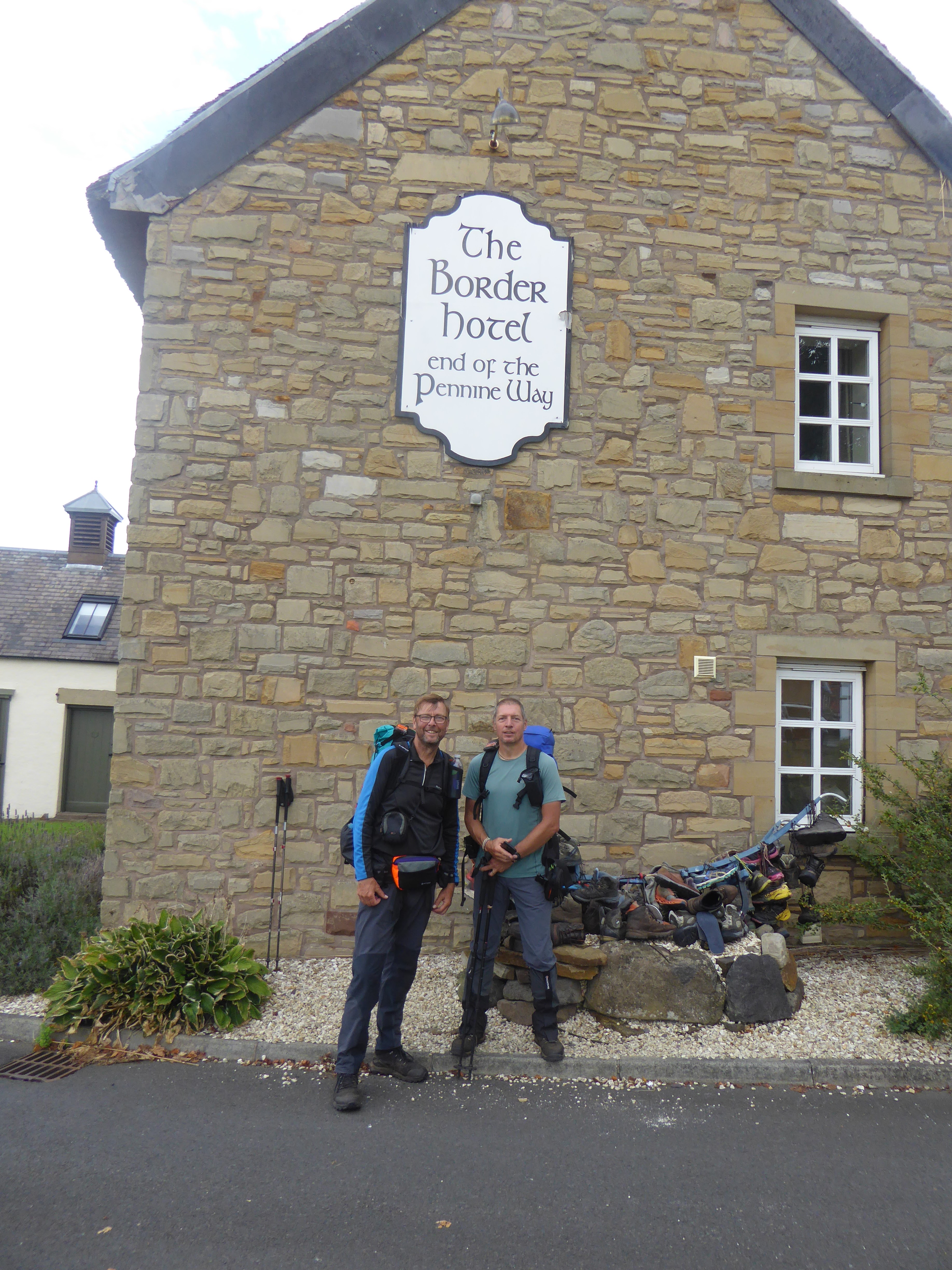
The End: The Border Hotel, Kirk Yetholm

Friday 12 November 2021

Pennine Way Days 13 to 15 Knarsdale to Byrness: In which I crack a good joke

Day 13 Knarsdale to Twice Brewed

25.9 km, 740 metres ascent, 8 hours 30 minutes

The Pennine Way follows the Roman vallum (ditch) after Greenhead golf course: clearly this bit isn't walked much

As I write, autumn is not doing that romantic "season of mist and mellow fruitfulness" stuff. Rather, it is doing the less poetic and more typical, "season of grey cloud and occasional drizzleyness". This is not helpful when reflecting back on the leg of the Pennine Way from Knarsdale, which is thought by many to be the most dreary of the whole 270 miles. 

Actually, in my opinion it wasn’t the most dreary. That was yet to come.

We set off from Knarsdale. The way as far as Greenhead was dull, with little excitement or merit, but I was thankful that the paths, such as they were (for very often they were not in evidence) were relatively dry. Some boggy sections, yes, but not as bad as most of the guide books made out. Whilst I have various pictures in my mind of the landscape we crossed during the morning I do not have the literary skill to describe them. Grass, reeds, green-brown, a little tarmac, a gravel track and then a descent to the A69, a locked five bar farm gate which had to be climbed, despite this being a major National Trail. This was followed soon after by a walk across the golf course at Greenhead, with more obstructions on the Way at this point, including a barbed wire fence. And no, our navigation wasn’t at fault. The photo above, taken immediately after the golf course shows how little this stretch is walked. Walkers have clearly been forced to divert on to the adjacent Hadrian’s Wall Path rather than following the Roman Vallum, the actual route of the Pennine Way here. I have contacted the Rights of Way people at Northumberland County Council about this twice now. Despite their promised ten day response time I’m still waiting, almost two months later.

An old wall

Just above Greenhead is Thirwall Castle. John raced around it recreating some of the photos he had taken there in the 1980s. I plodded on, in the knowledge that he would not struggle to catch me up. We then came to a far more interesting stretch of the Way which for the next several miles followed this old wall thing. I really ought to do some research and find out who built it, when and why. I heard a whisper that it was put up by some chap called Hadrian who led the set building team for the film ‘Robin Hood Prince of Thieves’ starring Kevin Costner, and abandoned once filming was over. I think that may well be true.

Lots of short, steep uppiness and downiness bits followed, and then a longish downiness bit to our camp site at Twice Brewed. The grass pitches suffered from either bogginess or slopeyness and midgeyness, but the site does have a very good communal bit with a kettle and things, and turned on radiators which John and I purloined and covered in rinsed through socks and shirts. Better still, the camp site is only about half a mile from the Twice Brewed pub so we spent the evening pumping money into the local economy and real food and beer into our stomachs.


Twice Brewed Camp Site

Day 14 Twice Brewed to Bellingham

24.9km, 618 metres of ascent, 7 hours 50 minutes

Hadrian's Wall looking to Crag Louth

We climbed back to the old wall which really is spectacular in places, and as I walked along it I marvelled at the skill of the set builders who had worked for Hadrian on ‘Robin Hood Prince of Thieves’ and also thought about all those actor luvvies and how tough they must have found it, sitting and sleeping in their massive trailers in between filming in the harsh Northumbrian climate. I had been told by John that we would come to “that Sycamore” today. As my camera clicked away at the tree from a good view point above it John didn’t bother stopping but waited for me in the gap below.

“Didn’t you want to get a photo of the tree”, I said. “Kevin Costner and Morgan Freeman rode past it you know”.

“Ermm. Not that tree they didn’t. Sycamore Gap is twenty minutes further on." Well trees all look the same to me, but John has a degree in Forestry so I didn’t argue. 

That Sycamore: Kevin Costner has a lot to answer for

Soon after the genuine film star tree we left the old wall thingy and headed on to what I came to regard as the worst section of the whole of the Pennine Way. I knew much of it would be in forestry plantations and envisaged long, easy-but-dull walking on forest tracks. And indeed, that was the case as we entered the forest. The route then degenerated into narrow, wet, boggy paths that seemed endless.


Into the forest: unfortunately the track soon deteriorated. Significantly

I decided to cheer us by thinking up and recounting a very good joke. It was a joke that could have been made by one of my heroes, a man I try to emulate. My life role model (not a ‘life model’ as I always wear clothes in public).

“Who is that?” I hear readers cry.

Well it is, of course, none other than Mr George Pooter, the hero of ‘Diary of a Nobody’ by George and Weedon Grossmith. Mr Pooter, like me a nobody, was an Edwardian with a splendid sense of humour. He used to crack very good jokes to entertain his wife Carrie and son Lupin. For reasons that escape me, Carrie never laughs, even though these jokes had Mr Pooter (and me whilst reading the book) in absolute stitches. You really must read it if you haven’t already done so. It will have you in hoots. I often make jokes in the same style to Mrs Fellbound. They can be so funny she usually leaves the room immediately I announce the punch line, I assume because she feels it unbecoming for someone of her refined breeding to belly laugh in front of her husband.

Anyway, you will recall that John had bought new boots a few days back after ruining his original pair in a drunken stumble at the Tan Hill Inn. The new boots were made by Hoggs of Fife. Now they were very good boots and very reasonably priced but being new, and higher than his normal mids they were causing the poor chap quite some ankle pain. My joke, I knew, would take his mind off his not inconsiderable discomfort.

“Those boots”, I cried, "made by Hoggs of Fife. Are they still hurting?”

“They are indeed”, replied the poor chap.

“Well then", I said, "perhaps we should refer to the makers as “The Pigs of Fife”.

Well, I couldn’t stop chuckling for the next few kilometres and kept referring to his boots as “The Pigs”. I’m pretty certain John was very amused and that my joke had done wonders for his morale. As I laughed away to myself he walked off ahead of me, my joke clearly having taken his mind off the pain, which must have been slowing him down but now he was able to race on at pace again.

This was the only stream of any width we had to wet our boots in on the whole Pennine Way. And once over we realised we were a couple of hundred metres off the path and we had missed the footbridge.


A small rocky outcrop. Possibly the only interesting feature between Hadrian's Wall and Bellingham

We arrived at the Camping and Caravanning Club site on the outskirts of Bellingham. The facilities there are brilliant for backpackers, which was just as well as the evening walk to the village to support the local economy was rather longer than we would have wished.


The Bellingham Camping and Caravanning Club Site


Bellingham to Byrness

26km, 575 metres of ascent, 7 hours 20 minutes

Above the mist, looking back towards Bellingham

I hadn’t especially been looking forward to this day, as much of it was to be in forestry plantations again. However, it turned out to be delightful and one of the most enjoyable.

After the steep pull up the lane from Bellingham we crossed fields and attractive moorland. On crossing a footbridge we came across a plastic bag pinned to the wooden rail labelled “For Danielle”. It looked like it contained a bar of chocolate. Later there was another bag for Danielle containing what looked like mints. We speculated. The mystery would be resolved two days later.


Crossing pleasant fields and moorland beyond Bellingham

In no real hurry today, we lazed in the sun on the top of Whitley Pike, the peace somewhat spoilt by the noise of military helicopters circling overhead for well over half an hour. But the weather was good, it was dry underfoot, and the scenery pleasant. After skirting Padon Hill we made a steep descent followed by a rougher and steeper ascent to the edge of the forest that would take us to Byrness.


On the summit of Whitley Pike

From the edge of the forest the tracks were both easy and excellent all the way to Byrness. I decided against jokes today. With hindsight I guess I must have felt like Churchill after his “This was their finest hour”, speech made in 1940 after Dunkirk. He probably realised he could never surpass such oratory. Similarly, if I lived a thousand years I could never achieve such comedic heights as on the previous day. 

At one stage John produced a photograph he had taken in the forest back in the 1980s and announced he was going to find the very same tree and take a photograph by it. He then noticed that the conifers today were the same height as in 1984. I told you he has a degree in Forestry. He’s no mug when it comes to trees. A plantation had matured, been cut down, replanted and re-grown since his last Pennine Way.

Heading through the forest to Byrness

Byrness and the Forest View Walkers Inn. A slightly weird but delightful set up. We had pre-booked to camp in the back garden, which is free if you also book an evening meal.  There were half a dozen or so other walkers there, only three of us camping, though, and almost all the others using the baggage transporting and Bed and Breakfasting services along the sections of the Pennine Way they were hiking. The place was taken over by Laura and Oliver earlier in 2021. Laura does the front of house stuff and is lovely, and couldn’t do enough to look after the guests. The dinner and beer were good. I would highly recommend a stop here if you are walking in the area.


The Walkers Inn, Byrness


Camping in the garden: John on his daily sleeping bag airing routine


Wednesday 27 October 2021

Pennine Way Days 9 to 12: Deepdale Beck to Knarsdale: The Kindness of Strangers

Day 9 Deepdale Beck to Middleton-in-Teasdale

14.1km, 388 metres of ascent, 3 hours 55 minutes

Near Blackton Reservoir, Baldersdale

This was a short day of pleasant walking but not especially memorable. We passed through Hannah's Meadow (that's a linky thing there about Hannah) in Baldersdale. John had camped at Hannah Hauxwell’s on one of his Pennine Way walks in the 1980s before television made her an unlikely star. John walked with his patched up boot, fortunately with the duck tape still holding the sole to the upper.


Grassholme Reservoir - evidence of our unusually dry summer

John's Boot, illustrating one of the many uses for duck tape - I always carry some wrapped around my walking poles

Middleton-in-Teesdale. We arrived well before midday and headed to the first cafĂ© we saw. At the counter my brain said “We would like two large mugs of tea and two wholemeal rolls, the latter filled with the finest of fried local pork produce topped with a Size 3 free range. Oh, and kindly ensure that the roll is generously, nay lavishly spread, with lashings of unsalted butter and that the whole ensemble is then smothered in the very best tomato ketchup that Heinz produces. And make it snappy my good woman for our need is greater than the old ladies sitting here who have done nothing other than pop to the local Co-op this morning”. In fact I simply asked for a couple of mugs of tea with bacon and egg rolls and a plastic sachet of ketchup. But they still tasted damned good.

The Teesdale Hotel, our luxury* accommodation for the night would not allow us to enter until 3 pm. This gave time for John to pop to Raine’s Hardware store to try to buy boot repair products.

(* The use of the word "luxury" may not be entirely accurate. "Adequate" might have been better, although to be fair hospitality venues have had a torrid couple of years)

Raine’s is the sort of hardware shop that appeals to the middle aged and elderly. One of those places you find in many small towns. They sell everything, from children’s toys in faded boxes that have sat in the shop window since 1969, to plastic flowers, to dustbins, assorted nuts and bolts that can be bought singly rather than in packs of two hundred…and…amazingly, and hidden away upstairs in Raine's,…walking boots. Eureka. John now had the choice of two pairs. One pair by a well-known manufacturer costing two squillion pounds and one by “Hogg’s of Fife” costing somewhat less. Having lots of pairs back at home, and only needing something to last for another week he opted for the latter, and parcelled his ruined pair up to post home to do battle with the manufacturers, if necessary with the support of the Sale of Goods Act.

Apart from the normal B and B stuff like the much needed shower, washing our smalls and then heading off to stock up at the Co-op, the only other noteworthy mention of our stop in Middleton was the fabulously delicious meal we had at Forrester's French Bistro opposite the hotel. I had scallopy things followed by maple smoked duck breast in some saucy* stuff if you’re interested. You’re not? Well I won’t tell you what I had for pudding then.

(*That's not "ooo matron saucy", it's sauce saucy, sauce in this context meaning very fancy gravy). Do click on the linky thing there. 


Day 10 Middleton-in Teasdale to High Cup Nick

26.5km, 688 metres of ascent, 7 hours 35 minutes

What a brilliant day's walking, in great walking weather. Mainly dry, a little sun, and just the right temperature. Absolutely fabulozy. Much of the way followed the River Tees upstream.


Low Force(ish) on the River Tees


High Force (with no "ish" about it)


Following the Tees upstream

The scenery was wonderful. And it features well known landmarks such as Low Force, High Force and then onward through the Upper Tees Valley, which feels pretty remote and wild apart from the occasional farm. The path gets quite bouldery in places and is a little tricky for the unbalanced (mentally and physically in my case). John entertained himself by going ahead and then taking photos of me each time I slipped, grimaced or generally made myself look a pillock. He seemed to take delight in sneaking these out on Facebook at the earliest opportunity. Cauldron Snout was reached. It is very impressive. The path up the side involves a scramble, which would be easy wearing just a day pack but far less so for an old bloke with a large backpack. John floated upwards and was at the top whilst I was still huffing and puffing well below. I’ve commented before on John’s ability to go up fairly steep rock without touching it with his hands. By coincidence I came across this two minute video of legendary rock climber Johnny Dawes the other day. Click on that linky thing and be amazed. I am not suggesting Johnboy could manage a full on rock climb without using his hands but the video is still worth a watch in its entirety for the jaw dropping skill in evidence.

The Upper Tees Valley


Cauldron Snout

The weather was starting to look ominous by the time we arrived at High Cup Nick. We got the Duomids pitched on a platform high above the east side of the valley and then headed off to take photographs of this spectacular feature. This is a very definite highlight of the Pennine Way, but the whole walk from Middleton is just superb. And as it turned out it was a good job we took our pictures then for soon after the wind came up and the heavens opened. Big time. And as for the weather the following morning…


Our two tents are pitched on the shelf in the background above High Cup Nick


John getting up close to take photos


High Cup Nick

Day 11 High Cup Nick to Garrigill

31.3km, 1090 metres of ascent, 10 hours 30 minutes

The morning after the night before

…it was horrid. Clag, wet and windy. Not a sign of High Cup Nick. It must have been stolen overnight. We had to lose a great deal of height before we were out of the cloud but were in Dufton by 9.15am. The cafĂ© didn’t open until 10. As we stood outside ready to break open a snack the owner arrived to set up. I put on a very sad face and shivered a bit and so she let us in and kindly had bacon and sausages sizzling in the pan within minutes. 

The rest of the day, for me, was a tiring slog. We ascended into the cloud again as we made the long climb up towards Knock Old Man and then stayed in this foulness for several hours, with the wind becoming increasingly fierce as we crossed much featureless ground. By the summit of Great Dun Fell the wind was gusting, I guess, to gale force. We plodded on over Little Dun Fell and on to the summit of Cross Fell, the highest point in the Pennines, at just under 3000 feet above seal level. No views, of course. The experience at the top was almost surreal. We arrived just before a large party who had walked up from Kirkland. They were all Christians on an annual pilgrimage in honour of some allegedly well known historical Christian figure with associations to Kirkland. Not well known enough, though, for me to have heard of him. The conversation around us in the wind shelter became increasingly bizarre as well as intense and philosophical as theology was discussed by the group, in between musings about Manchester United’s chances that afternoon as at least one of them was a fervent supporter.

The summit of Cross Fell


Looking surprisingly chipper on the summit of Cross Fell

We headed onwards and downwards. The plan had been to wild camp by Greg’s Hut, the bothy on the side of Cross Fell, or just beyond. I can’t quite remember why we didn’t. I know we weren’t keen on staying in the bothy as it was a Saturday and we expected it could be busy. As we walked on it became increasingly clear that we weren’t going to find a decent camp spot. Plan B was to get to Garrigill where camping at the village hall is possible. This added 10km to our planned day, really too much for me but I tried to be a brave little soldier. In Garrigill we asked a lady dressed up in a party frock where the hall was. She pointed it out, mentioning that the 'do' there that evening was to mark the christening of her son. The caretaker came over with us to show us where to pitch, how to pay the modest fee (“just pop it in the honesty box”), and gave us the combination code to the locks on the hall so we could use the showers, toilets and kitchen.

Camped at the back of the Village Hall in Garrigill

We pitched at the back of the hall as instructed, with the children from the party playing on the swings by our tents and dads in their best suits standing around chatting and knocking back cans of lager. All very weird but very friendly. I was dog tired. It was late and we still had to cook. At least there were picnic tables near the tents so we would have more than the usual levels of comfort.

John speculated. “I’ll bet there's far too much food in the Hall,” he said. At that very moment the lady whose party it was appeared at the tents. “We’ve got far too much food in there”, she said, and handed us a plate of sandwiches, rolls, pizza slices and cakes. No need to cook. A few minutes later trifles appeared. I went inside to thank the lady doing the catering. “Ooo you’ve not had coffee yet”, she said, “or would you prefer tea?” The people of Garrigill are wonderful. As is their village hall for camping. Do remember this if you are in the area.


Day 12 Garrigill to Knarsdale

18.6km, 325 metres of ascent, 6 hours 45 minutes (including a very long stop in Alston)

The South Tyne Valley near Garrigill

The weather was fine again. The walk to Alston, following the South Tyne River, was pleasant. Alston’s cafĂ©s did not appear to open on a Sunday but eventually we found one and also visited the Co-op and the Spar to fill our food bags. And pies may well have been purchased. In my case it was filled with black pudding and pork and lovely jelly stuff. Then it was off along the South Tyne again, with the Way making an uphill detour to walk by Whitley Roman Fort. Unspectacular walking, but not unpleasant and still dry underfoot. My theory is that if the Pennine Way was being devised today most of the route from Alston to Greenhead would change and it would follow the much newer South Tyne Trail along the old railway line to Haltwhistle then cut up to Hadrian’s Wall. But it doesn’t, although for one short 20 minute stretch as we neared Knarsdale, I did follow the South Tyne Trail whilst John, being a good boy and a purist, headed up some fields and then back down again along the Way proper.


This is that old railway viaduct that's always photographed on this stretch of the Way, possibly because so few features stand out


Snack stop by the South Tyne

The plan was to camp at Stone Hall Farm at Knarsdale. We arrived. The farmer’s wife explained that they hadn’t done camping for two years, “too much hassle since Covid” apparently. This would mean walking on and trying to find a wild camp spot. I did my best to look tired and generally pathetic. Not difficult. I think I even managed to make my bottom lip start to wobble like a small child who has been told that he can’t have any sweets. It worked. She pointed to a field we could camp in and took us to the outside tap to fill up our water bottles. More kindness.

We spent the late afternoon playing ‘What time is it Mr Wolf’ with the large numbers of sheep in the field. They stood in a long line watching us at the tents. Each time we looked away they moved a little closer. We would look round and the line of sheep would be standing still, only closer, watching us. We would turn our backs. Repeat. They got closer and closer. Eventually they would run off. A few minutes later they would do it all over again. Well it must be dull being a sheep in Knarsdale.

If you look pathetic enough you can blag a spot in a friendly farmer's field


Happy bunny eating the last of his black pudding pork pie